The Big Boom

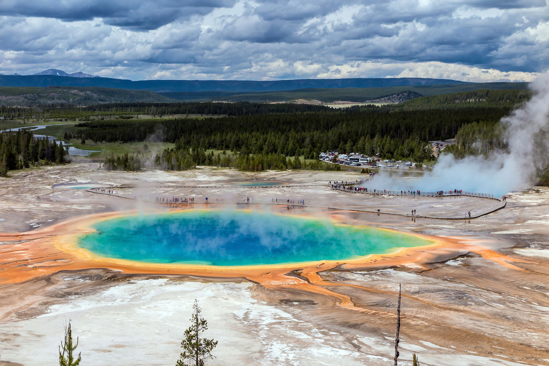
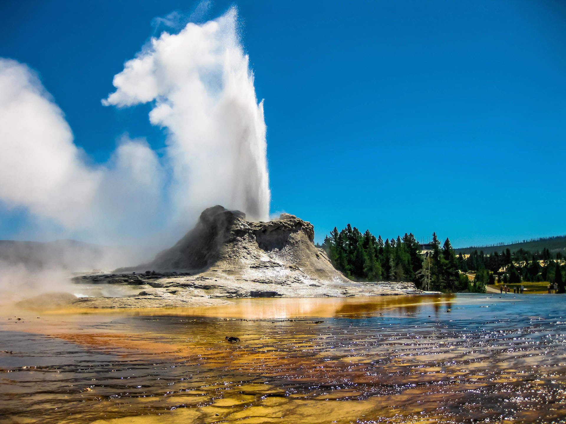
Yellowstone National Park attracts over four million visitors each year. Swarms of people flock to the park to see its many natural wonders. Hot springs filled with boiling water host brightly colored bacteria. Geysers shoot heated water hundreds of feet into the air. Mudpots bubble along, giving off a rotten-egg smell. All the while, a giant pool of magma quietly churns just a few kilometers beneath the park, giving off heat that fuels the hot springs, geysers, and mudpots. You may not realize it when you are standing in the park because the crater is at ground level, but Yellowstone is actually an active volcano measuring about 3,960 square kilometers (1,496 square miles).

Does it surprise you that a national park is home to an active volcano so big it almost spans the borders of the park? You’re not the first person to be curious. Scientists have had their eye on Yellowstone’s volcanic activity for a long time.

This map compares the size of Yellowstone National Park and the Yellowstone Caldera.
This map shows resulting ash-fall boundaries for major volcanic eruptions from Yellowstone.

According to their research, the Yellowstone volcano has erupted cataclysmically three times in its history. The first major eruption occurred 2.1 million years ago; the second, 1.3 million years ago; and the most recent, 640,000 years ago. By analyzing soil layers, scientists were able to conclude that the first eruption was so powerful that it spread ash as far as Missouri. In fact, Yellowstone is classified as a potential supervolcano, meaning that it could send out more than 240 cubic miles of magma in an eruption. In other words, it could cover the United States in a layer of magma five inches deep!

The question on everyone’s mind is: Will Yellowstone erupt again? And if it does, will it erupt with the same violent, destructive force of the last three major eruptions?

It is impossible for scientists to predict whether or not Yellowstone will erupt again. Even if scientists knew that Yellowstone would erupt, they wouldn’t be able to predict exactly when. The most that scientists can do is continue to monitor the volcano for earthquake activity and changes to the magma that supplies the volcano. When it comes to volcanic eruptions, sometimes the best defense is education, followed by evacuation. Researchers have several tools at their disposal to help them keep a close watch on Yellowstone.

First, Yellowstone National Park has a permanent volcano monitoring network to help scientists keep their finger on the seismic pulse of this region. Rapid swarms of earthquakes in a short period of time usually mean a volcanic eruption is about to happen. If scientists notice earthquakes happening in quick succession, they can warn visitors and nearby residents to evacuate the park.

Second, scientists use technology to image and monitor the pool of magma situated below Yellowstone National Park. Luckily, researchers get a little help in this task from seismic activity that happens naturally. Yellowstone experiences thousands of earthquakes each year. Scientists record these earthquakes using seismometers, machines that track vibrations of the ground. Seismic waves from an earthquake will travel more quickly through cool rock and more slowly through magma and hot rock. By studying how the waves from earthquakes travel, echo, and spread, scientists can figure out where the pool of magma sits, how big it is, and what shape it is. These characteristics help scientists predict how big an eruption might be and what type of eruption might occur.

Third, scientists use satellites to measure how much the pool of magma causes the crust above it to rise and fall. Even from all the way in space, satellites can detect small changes in ground movement that we can’t even see with our naked eyes.

As of now, scientists predict that there is only a 1 in 10,000 chance of a supervolcanic eruption at Yellowstone. What is more likely is an eruption on a smaller scale that still includes typical eruption events such as lava flows and clouds of ash. This type of eruption, while destructive, would likely only have local effects. For now, Yellowstone continues to delight visitors with natural beauty fueled by the hidden power of Earth’s interior.

Yellowstone's Grand Prismatic is one of the world's largest hot springs.
(Benny Marty)

Tamu Massif

A Giant in the Deep

Investigate the largest volcano on Earth hidden far beneath the ocean.

The Mid-Atlantic Ridge

40,000 Mile Long Volcano

Investigate mid-ocean ridges and the fascinating life that thrives in this environment.

San Andreas Fault

Shake Alert

Investigate how technology is providing warning to residents living along the San Andreas Fault.

Maar Volcanoes

Unexpected Eruptions

Investigate one of the most unpredictable types of volcanoes in the world.

Fire Under the Ice

Volcanoes in West Antartica

Investigate how scientists detected potentially active volcanoes underneath sheets of ice in Antarctica.

Yellowstone

A Sleeping Supervolcano

Investigate the volcano lurking underneath one of the most popular national parks in the United States.

  • anomaly

    noun

    Something that is unexpected, abnormal, or differing from what is common.

  • crater

    noun

    A bowl-shaped hole in Earth's surface.

  • earthquake

    noun

    A sudden shaking of the ground producing seismic waves or vibrations, which may result in destruction. An earthquake occurs when slabs of rock suddenly slip past each other at a break in Earth's crust, called a fault.

  • geyser

    noun

    A type of hot spring that sends heated water and steam up into the air.

  • lava

    noun

    Hot, molten rock that has reached Earth's surface through volcanic eruption or a crack in the crust.

  • mid-ocean ridge

    noun

    A long line of mountains on the seafloor, formed by divergent plate boundaries and the upwelling of magma. Seismic and volcanic activity are common along these regions.

  • seismometer (or seismograph)

    noun

    A tool to measure the movement of the ground. This instrument can measure seismic activity, such as the force and duration of an earthquake.

  • tectonic plate

    noun

    Large, slowly moving, slab of solid rock that make up Earth's crust.

  • convergent boundary

    noun

    A location where tectonic plates collide with each other. When two continental plates push toward each other, they fold together and form mountain ranges.

  • crust

    noun

    The outermost layer of Earth. The crust is the coolest and thinnest layer of Earth, ranging from about 5 to 70 km thick. The crust is divided into large slabs of rock, called tectonic plates.

  • eruption

    noun

    Molten rock, ash, and steam ejected from a volcano or geyser.

  • horizontal

    adjective

    At a right angle to the vertical or parallel to the ground level.

  • maar

    noun

    A broad volcanic crater typically filled with water. Maars are created from the explosion that occurs when groundwater meets hot magma.

  • p-wave

    noun

    A type of seismic wave, called primary waves, because they are the first waves from an earthquake to reach a seismograph. P-waves are compressional waves, shaking the ground back and forth, towards and away from the direction the wave is traveling.

  • steam

    noun

    Water in the gas phase.

  • transform boundary

    noun

    A location where tectonic plates slide horizontally past one another. The plates grind together causing frequent earthquakes.

  • convergent with subduction boundary

    noun

    At convergent plate boundaries with subduction, plates push together, and one plate moves underneath the other. This type of boundary may result in the formation of trenches, volcanoes, islands, and earthquakes, which can trigger tsunamis.

  • divergent boundary

    noun

    A location where tectonic plates move away from one another. When plates move apart, lava and magma rise to the surface and make new rock. This type of boundary may result in the formation of small volcanoes, shield volcanoes and rift valleys.

  • fault

    noun

    A fracture or crack in the rocks that make up Earth's crust.

  • hydrothermal vent

    noun

    An opening in the sea floor where magma meets water. This interaction causes heated water, filled with minerals, to rise up from the opening.

  • magma

    noun

    Hot liquid or molten rock located beneath the surface of Earth.

  • seismic wave

    noun

    The vibration from an earthquake that travels within Earth or along Earth's surface.

  • s-wave

    noun

    A type of seismic wave, called shear waves or secondary waves, because they reach a seismograph and shake the ground second, after an earthquake occurs. S-waves shake the ground perpendicularly to the direction the waves are traveling.

  • volcano

    noun

    An opening in Earth's crust which releases hot gases and molten rock.