If you had a 20 second warning before a major disaster, could you make quick decisions to get to a safer location? What if you only had five seconds? Or even just three seconds?

Over 75 million Americans, across 39 different states, live in areas that are prone to seismic, or earthquake, activity. The Federal Emergency Management Agency (FEMA) estimates over $5 billion in losses each year, in the United States, due to earthquake activity. An incredible 4 billion of those dollars comes from just the West coast of California, Oregon, and Washington.

The West coast is particularly geologically active. Thousands of small earthquakes occur in California each year. Some are so small that they are barely noticeable, while others cause substantial damage. One of the worst earthquakes in history was the Great San Francisco Earthquake of 1906.

Although the destruction and losses were catastrophic, scientists gained a lot of information from the event and it has helped future generations of geologists understand how Earth works.

A fault is a fracture or crack in the rocks that make up Earth's crust. At these locations blocks of rock move in a variety of ways.
Before Fault
Normal Fault
Thrust Fault
Strike-Slip Fault

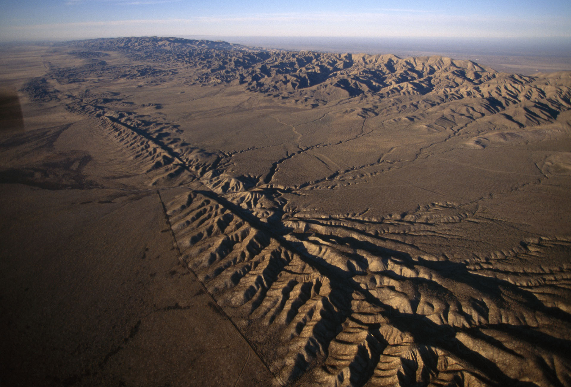
The San Andreas fault, located in California, sits at the boundary between the Pacific Plate and the North American Plate. A fault is a fracture in Earth’s crust consisting of a thin zone of crushed and broken rocks. The plates at this boundary move very slowly, almost as slowly as your fingernail grows. The slow motion along this plate boundary leads to frequent earthquakes. When two plates slide horizontally past one another, this is known as a transform tectonic boundary.

Earth’s outermost, rigid layer includes more than a dozen slabs of rock, called tectonic plates. Each of these tectonic plates is slowly and constantly moving. Many times, fascinating geologic events such as volcanoes, earthquakes and faults occur at plate boundaries, or where one tectonic plate meets another.

Destruction from the 1989 San Francisco earthquake caused more than $5 billion of damage along the San Andreas Fault System.
(Garry Gay)

Viewing the fault from overhead, an observer may notice a series of connected linear valleys, lakes, bays, and other landforms. Yet from the ground, the fault is hardly noticeable and can only be observed by examining specific landforms and geologic structures.

Earthquakes are inevitable. Earth’s internal energy will continue to cause shifts at Earth’s surface resulting in earthquakes. Though we cannot prevent earthquakes from occurring, we can use our scientific and engineering knowledge to make the best decisions for living in earthquake-prone regions.

Any warning at all has the potential to save lives, prevent injury, and prepare for potential damage.

With that goal in mind, scientists and engineers are developing and testing technology to provide coastal California with early warning alerts for earthquakes.

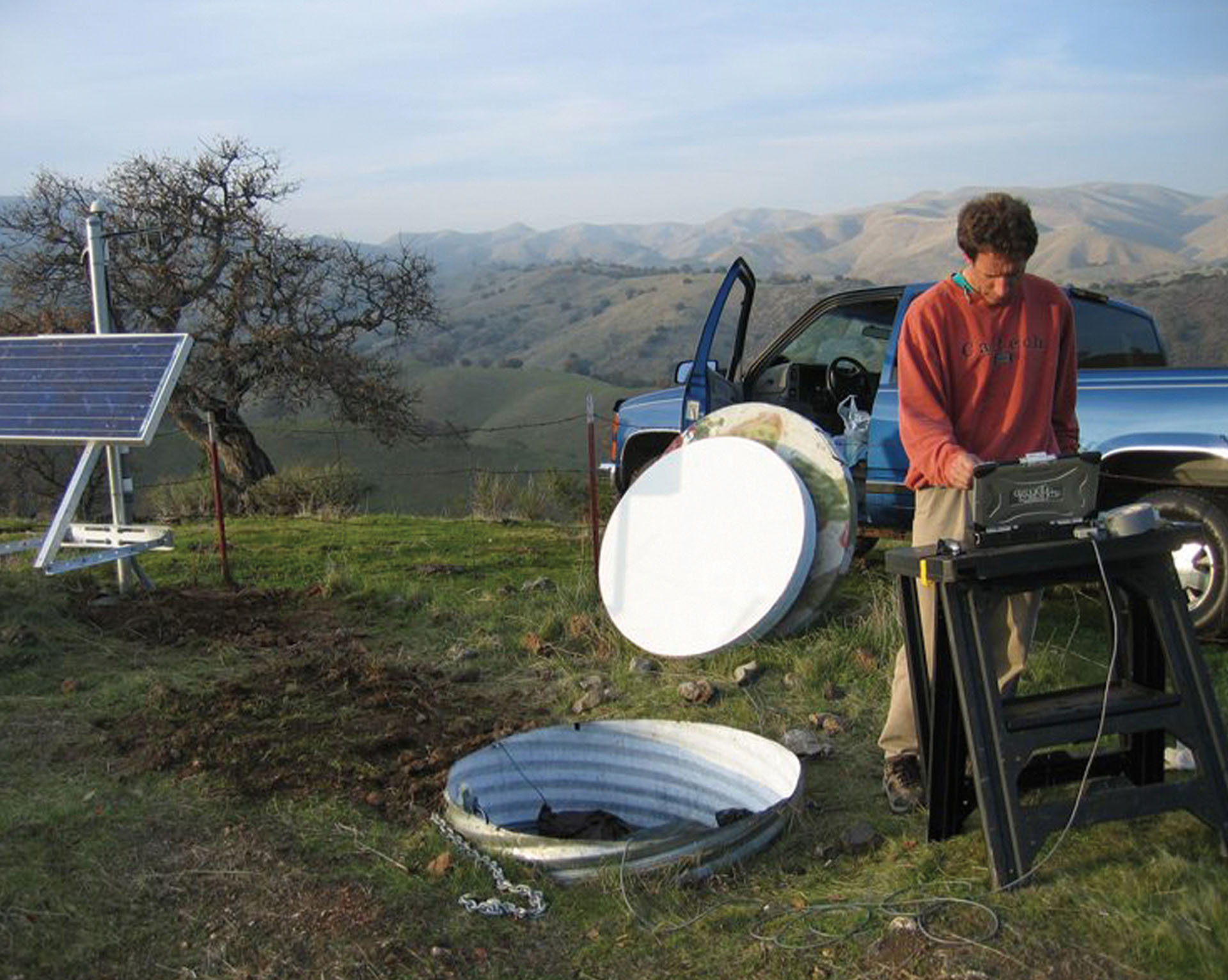
Areas along the San Andreas fault and throughout California have imposed building codes and regulations. Designing and constructing new buildings with earthquakes in mind is a good first line of defense. Additionally, developing seismometer networks provides scientists access to massive amounts of data about the location and type of earthquakes. This data has enhanced our ability to analyze and prepare for future events more accurately.

An aerial view of the San Andreas region shows the speed at which P-waves and S-waves travel. This map indicates the time it would take for seismic waves from a theoretical earthquake to reach San Francisco, Palo Alto, and San Jose.
P-waves are one type of seismic wave. They are also referred to as primary waves, because they are the first waves from an earthquake to reach a seismograph. P-waves are compressional waves, shaking the ground back and forth towards and away from the direction the wave is traveling.
S-waves are another type of seismic wave. S-waves are also called shear waves or secondary waves, due to the fact that they reach a seismograph and shake the ground second, after an earthquake occurs. S-waves shake the ground perpendicularly to the direction the waves are traveling.

The US Geological Survey (USGS) along with university partners are in the process of developing and implementing an early warning system called ShakeAlert. This system takes advantage of the ability of mobile phone technology to communicate information at a moment's notice. Seismometers can instantly detect shaking near the epicenter of an earthquake. Because ground vibrations spread at about one mile per second (much slower than phone communications), the ShakeAlert system is able to transmit information to surrounding areas before destructive shaking reaches them. The larger and more distant an earthquake is, the greater the possible warning time. In the best situation, the system can provide a warning several minutes before the earthquake hits an area.

ShakeAlert capitalizes on the fact that the first seismic waves, Primary waves or P-waves, rarely do the most damage. The technology uses information from P-waves and how they radiate from a given point to calculate intensity and location of an earthquake.

When large earthquakes are detected, the system lets residents in surrounding areas know that the stronger, but slower, S-waves and surface waves are on their way. The Secondary S-waves cause strong shaking, which is generally responsible for the most damage during an earthquake.

So think back to the three, five, or twenty seconds of warning presented at the beginning of this reading. In the same amount of time that it takes for you to check a text message, you could protect yourself by getting under a desk or stepping away from a heavy bookshelf. Next time you take three seconds for granted think about how valuable it could truly be. By issuing public warnings, ShakeAlert has the potential to change the way we prepare for and react to earthquakes.

Installing instrumentation, like this US Geological Survey Broadband Station, helps scientists track and measure seismic activity.
(Iris)

Tamu Massif

A Giant in the Deep

Investigate the largest volcano on Earth hidden far beneath the ocean.

The Mid-Atlantic Ridge

40,000 Mile Long Volcano

Investigate mid-ocean ridges and the fascinating life that thrives in this environment.

San Andreas Fault

Shake Alert

Investigate how technology is providing warning to residents living along the San Andreas Fault.

Maar Volcanoes

Unexpected Eruptions

Investigate one of the most unpredictable types of volcanoes in the world.

Fire Under the Ice

Volcanoes in West Antartica

Investigate how scientists detected potentially active volcanoes underneath sheets of ice in Antarctica.

Yellowstone

A Sleeping Supervolcano

Investigate the volcano lurking underneath one of the most popular national parks in the United States.

  • anomaly

    noun

    Something that is unexpected, abnormal, or differing from what is common.

  • crater

    noun

    A bowl-shaped hole in Earth's surface.

  • earthquake

    noun

    A sudden shaking of the ground producing seismic waves or vibrations, which may result in destruction. An earthquake occurs when slabs of rock suddenly slip past each other at a break in Earth's crust, called a fault.

  • geyser

    noun

    A type of hot spring that sends heated water and steam up into the air.

  • lava

    noun

    Hot, molten rock that has reached Earth's surface through volcanic eruption or a crack in the crust.

  • mid-ocean ridge

    noun

    A long line of mountains on the seafloor, formed by divergent plate boundaries and the upwelling of magma. Seismic and volcanic activity are common along these regions.

  • seismometer (or seismograph)

    noun

    A tool to measure the movement of the ground. This instrument can measure seismic activity, such as the force and duration of an earthquake.

  • tectonic plate

    noun

    Large, slowly moving, slab of solid rock that make up Earth's crust.

  • convergent boundary

    noun

    A location where tectonic plates collide with each other. When two continental plates push toward each other, they fold together and form mountain ranges.

  • crust

    noun

    The outermost layer of Earth. The crust is the coolest and thinnest layer of Earth, ranging from about 5 to 70 km thick. The crust is divided into large slabs of rock, called tectonic plates.

  • eruption

    noun

    Molten rock, ash, and steam ejected from a volcano or geyser.

  • horizontal

    adjective

    At a right angle to the vertical or parallel to the ground level.

  • maar

    noun

    A broad volcanic crater typically filled with water. Maars are created from the explosion that occurs when groundwater meets hot magma.

  • p-wave

    noun

    A type of seismic wave, called primary waves, because they are the first waves from an earthquake to reach a seismograph. P-waves are compressional waves, shaking the ground back and forth, towards and away from the direction the wave is traveling.

  • steam

    noun

    Water in the gas phase.

  • transform boundary

    noun

    A location where tectonic plates slide horizontally past one another. The plates grind together causing frequent earthquakes.

  • convergent with subduction boundary

    noun

    At convergent plate boundaries with subduction, plates push together, and one plate moves underneath the other. This type of boundary may result in the formation of trenches, volcanoes, islands, and earthquakes, which can trigger tsunamis.

  • divergent boundary

    noun

    A location where tectonic plates move away from one another. When plates move apart, lava and magma rise to the surface and make new rock. This type of boundary may result in the formation of small volcanoes, shield volcanoes and rift valleys.

  • fault

    noun

    A fracture or crack in the rocks that make up Earth's crust.

  • hydrothermal vent

    noun

    An opening in the sea floor where magma meets water. This interaction causes heated water, filled with minerals, to rise up from the opening.

  • magma

    noun

    Hot liquid or molten rock located beneath the surface of Earth.

  • seismic wave

    noun

    The vibration from an earthquake that travels within Earth or along Earth's surface.

  • s-wave

    noun

    A type of seismic wave, called shear waves or secondary waves, because they reach a seismograph and shake the ground second, after an earthquake occurs. S-waves shake the ground perpendicularly to the direction the waves are traveling.

  • volcano

    noun

    An opening in Earth's crust which releases hot gases and molten rock.